Here is a link for our full 12-day itinerary from Reykjavík.
It is the third day of our journey — we travel the south of the island with its majestic waterfalls, desert plains, and glaciers.
If you want to know what beautiful places we visited during the two previous days, click here. 😊
Best things to do in Iceland
Here we are in the heart of the matter — what to do when you are in Iceland?
Well, you are spoiled with choices, and that’s good. 😃 To help you pick, below you will find some places I visited and the activities I’ve tried. All you have to do is make your choice.
My personal opinion:
😍 Do not miss
😃 Go if you have time
😐 Not very interesting
😭 Unfortunately, we couldn’t do it
Day 3: Hella to Skaftafell – 240 km
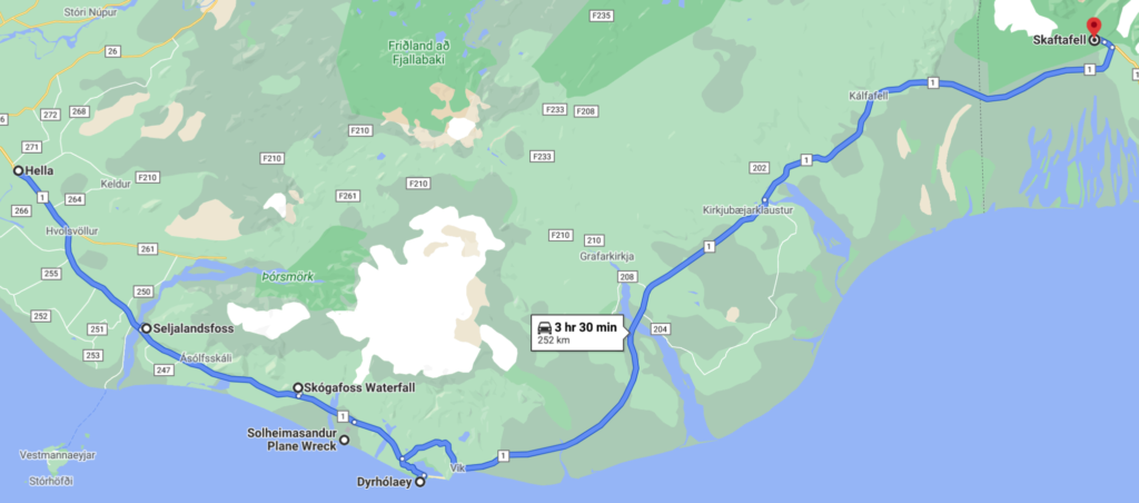
The stops we planned for the day
- Seljalandsfoss and Gljufrabui waterfalls
- Distance from Hella 35 km – 25 min
- Visiting time 45 min
- The waterfall of Skagafoss
- Distance from Seljalandsfoss 30 km – 25 min
- Visiting time 30 min
- Airplane wreck of Solheimasandur
- Distance from Skagafoss 11 km – 10 min
- Visiting time 3 hours
- Dyrhalaey Lighthouse Park
- Distance from Solheimasandur 17 km – 18 min
- Visiting time 30 min
- Skaftafell
- Distance from Dyrhalaey Lighthouse park 160 km – 2 hours
😍 Seljalandsfoss and Gljufurarfoss waterfalls
Seljalandsfoss waterfall


Sixty-five meters high, it flows along the Tröllkonugil, literally “the throat of the troll woman.” The name comes from a saga that tells the story of a troll woman trying to cross this canyon who turned back when she heard the church bells ringing in Asolfsskalar, a nearby village.
This waterfall’s peculiarity is that a path bypasses the waterfall, which allows us to admire it from a different angle. The sound of the fall like a roar of thunder, rainbows appearing and disappearing to the water’s rhythm, droplets of mist that swirl in the wind make the spectacle magical. I love this waterfall, and it was hard to get away from it.


The Gljufurarfoss waterfall
A few hundred meters farther, we discovered Gljufurarfoss waterfall. To get to its foot, you have to go up the river bed for a few meters by traversing a small canyon. It is not deep, and rocks allow crossing with dry feet.

But once inside, we found ourselves surrounded by rock walls, in the waterfall spray center. The atmosphere was icy, and the water droplets trickled down our faces. A cold hammam! If you don’t want to get too wet, I advise you to bring a raincoat.


😍 The Skagafoss waterfall

The waterfall is breathtaking. It is one of the largest in Iceland, with a width of 25 meters and a fall of 60 meters. A staircase on one side leads to an elevated platform overlooking the waterfall. The view from above was spectacular! The contrast between the calm and silent arriving river, which turns into a tumultuous waterfall whose sound echoes on the rock walls, is impressive.

Another scenery awaited us at its foot when we descended: a perfect rainbow.
Of course, the waterfall has its saga. If you have time for a treasure hunt, legend says that one of Iceland’s first settlers, Þrasi þórólfsson, hid one behind the waterfall. The inhabitants of the neighboring village managed to find the safe years earlier. But, they were only able to grab the ring tied on its side before it disappeared again into the raging waters of the waterfall. The ring was then given to the local church and is now in the Skógar Museum.


😐 Airplane wreck of Solheimasandur

Another picture of Iceland. The surreal vision of a white plane wreck set in the middle of a desert of black sand. A real sci-fi setting!


The plane’s discovery is unreal, but I admit that the 3-hour return walk (7.6 km) was a bit long and very monotonous. The trail was a straight line in the middle of a desert of black sand without any vegetation.
I do not know why the wreck was not removed, as its story is not extraordinary from my point of view.

Its story:
In 1973, a Douglas Dakota C-117 with seven crew members on board gradually lost altitude over the plain of Selheimasandur, forcing the pilots to land in urgency. End of the story! One can add that the reason for this accident remains uncertain. There are still two hypotheses, a mechanical failure or the pilot’s error accidentally switching to an empty fuel tank.
Fortunately, everyone survived!
😃 Dyrhólaey Lighthouse park
We covered the 17 km that led us to the park and reached the small hill where the Dyrhólaey lighthouse stood.

The lighthouse is located at the southernmost point of the Icelandic continent. Its white light, which flashes every 10 seconds, lets navigators know that they are approaching Iceland’s south coast.


The name Dyrhólaey, meaning “the hole in the door,” comes from the eroded volcanic rock arch seen in the ocean below the lighthouse.
In the distance — to the left in the photo above, one can see the black sand beach of Reynisfjara. This beach, famous for its basalt columns, offers a splendid view of “Reynisdrangar,” a rock formation rising off the coast.
You’d guess that they were sea trolls! Their story; they tried to reach the shore before sunrise, but were unfortunately struck by sunlight and turned into stone.


The cliffs that surround us, which have been a nature reserve since 1978, are a nesting site for birds between spring and summer.

😐 The village of Vik
We had read that it was a lovely and quaint little village that’s worth a visit. We drove around, took a picture of the church, bought some warm socks for our next day’s hike, and left.


Skaftafell
We stopped here for the night — not a village per se, just a few houses. The place’s fame is mainly due to its beautiful natural park, which we will discover the next day.
Day 4: Skaftafell to Höfn – 136 km

The stops we planned for the day
- Skaftafell and the two glaciers Vatnajökull and Falljökull
- Distance from our hotel 10 km – 10 min
- Visiting time 6 hours
- Breiðamerkurjökull, Jökulsárlón the glacier lagoon, and Diamond Beach
- Distance from Vatnajökull Glacier 56 km – 47 min
- Visiting time 1 hour
- Hofn
- Distance from The Beach at The Diamonds 80 km – 1 h 10
😍 Skaftafell and the two glaciers Vatnajökull and Falljökull

Before introducing the glacier Falljökull and the hike we did, let me tell you about Skaftafell National Park. It is a beautiful park located at the foot of the largest glacier in Europe, Vatnajökull. Both of them are national treasures.
To learn more about the glaciers and our beautiful hike, click here.
😭 The hamlet of Hof
A few kilometers south of Skaftafell is the hamlet of Hof. This village is known for its beautiful grassy roof chapel, and its cemetery with its tombs also covered with grass. Unfortunately, when I heard about it, we had already left. It is next to Skaftafell, so feel free to take a little detour.
😍 Breiðamerkurjökull, Jökulsárlón the glacier lagoon, and Diamond Beach

Jökulsárlón, literally “the glacier lagoon,” is the best known and largest of Iceland’s pro-glacial lakes.


Blocks of ice break off from the front of the Vatnajökull glacier — more specifically from its glacial tongue, Breiðamerkurjökull — and drift on the lake. They have different sizes and shapes and erode over time. When their size allows, they descend through the river that connects the lake and the sea. Then, tossed by the waves, they are washed up on the black sand beach. It was this show that gave the beach its name, “Diamond Beach.”


The lagoon’s evolution is impressive. When the first settlers arrived in Iceland in 900 AD, the glacial tongue’s edge was 20 kilometers farther north. During the Little Ice Age from 1600 to 1900, cold temperatures allowed the glacier to grow up to 1 km from the coast. But the following rise in temperatures led to further changes. Around 1934, Ice calving made Breiðamerkurjökull recede rapidly, creating the lagoon. Its size has increased from 7.9 km² in 1975 to 18 km² today.
😃 Eldgájarhraun lava craters
On the way, we took a short break at the Eldgajarhraun craters. We saw the sign for the site from the road, and it was an opportunity for us to stretch our legs and learn a little more about Iceland.

Eldgjá is a volcano and a canyon. It is also the largest volcanic canyon in the world. When we started crossing this region, we were surprised by the relief all around. The nearby volcano’s multiple eruptions destroyed all the vegetation, which gave the impression of strolling a lunar landscape.


The first eruption of Eldgjá took place in 939. The lava surface’s extent was approximately 800 km² or about 18 km3 of magma that poured out of the earth.


It is on this site that a monastery for the Augustinian monks was created in 1168. It sheltered the monk Eysteinn Ásgrímsson (1310 – 1360) who allegedly beat the Father Abbot of his monastery and put in irons for this disobedience.
He would later become the author of “The Lily,” a work considered to be the best religious poetry in Iceland during the Middle Ages. It is also commonly said that “every Icelander wished he had written it.”
For the anecdote, it would also appear that, at that time, the monks had unconventional relations with the neighboring nuns!
Höfn
This fishing village is located at the southeastern tip of the Vatnajökull Glacier. The city is not very big but offers all the primary services. From Höfn, you will have a fantastic view of the Vatnajökull glacier to the north.
In recent years, the city has made lobster a central part of its image, holding a “lobster festival” every summer.
Conclusion
I didn’t expect to find so many different landscapes in Iceland. In the south, the part we’ve just crossed, the multiple volcanic eruptions have ravaged much of the territory. Another cause responsible for this destruction dates back to the Vikings’ invasion. When they arrived, they cut the forests barren to manufacture their longships, and their herds of sheep sacked the plains. Today, it is still tough and slow to reforest the country, and the authorities are concerned about this problem. One can notice it when hiking in the mountains where it’s forbidden to leave the trails to preserve the flora.
I think our next leg will lead us to other sceneries. After those two days filled with discovery and wonder, we can’t wait to continue our journey and see what Iceland still has in store for us.
